
Topografisk kort Oxted
Klik på kortet for at se højden.
Om dette kort
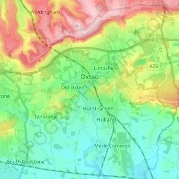
Navn: Topografisk kort Oxted, højde, terræn.
Sted: Oxted, Tandridge, Surrey, England, United Kingdom (51.21233 -0.03626 51.28976 0.01667)
Gennemsnitshøjde: 128 m
Minimum højde: 54 m
Maksimal højde: 271 m
Andre topografiske kort
Klik på et kort for at se dets topografi, dets højde og dets terræn.
Caterham
United Kingdom > England > Surrey > Tandridge
In 1840 Caterham contained a total of 477 residents (figures taken from that census, compiled in an 1848 topographical encyclopedia) and in 1848 468 acres (189 ha) of its 2,386 acres (966 ha) were common land. Similar to today, 175 acres (71 ha) mostly steeper acres were woodland.
Gennemsnitshøjde: 157 m
Botley Hill
United Kingdom > England > Surrey > Tandridge
Botley Hill is a Marilyn (a hill with topographic prominence of at least 150m), and the third highest point in the county (after the peaks of Leith Hill south of Dorking and Gibbet Hill in Hindhead, both on the Greensand Ridge).
Gennemsnitshøjde: 206 m
Caterham
United Kingdom > England > Surrey > Tandridge
In 1840 Caterham contained a total of 477 residents (figures taken from that census, compiled in an 1848 topographical encyclopedia) and in 1848 468 acres (189 ha) of its 2,386 acres (966 ha) were common land. Similar to today, 175 acres (71 ha) mostly steeper acres were woodland.
Gennemsnitshøjde: 157 m