
Topografisk kort Limpsfield Chart
Klik på kortet for at se højden.
Om dette kort
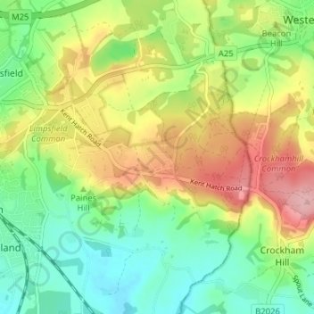
Navn: Topografisk kort Limpsfield Chart, højde, terræn.
Gennemsnitshøjde: 126 m
Minimum højde: 66 m
Maksimal højde: 214 m
Andre topografiske kort
Klik på et kort for at se dets topografi, dets højde og dets terræn.
Warlingham
United Kingdom > England > Surrey > Tandridge
Elevations vary from 110m AOD at Woldingham Road, at the southernmost point of the parish, with a gentle increase in height through the village along the main road heading to the southeast, to the highest elevation (199.6m) at Limpsfield Road.
Gennemsnitshøjde: 163 m