Geolocate

Topografisk kort Dyrham

Klik på kortet for at se højden.

Om dette kort

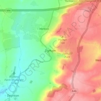
Navn: Topografisk kort Dyrham, højde, terræn.

Sted: Dyrham, South Gloucestershire, West of England, England, SN14 8HN, United Kingdom (51.46194 -2.39997 51.50194 -2.35997)

Gennemsnitshøjde: 139 m

Minimum højde: 68 m

Maksimal højde: 218 m

Andre topografiske kort

Klik på et kort for at se dets topografi, dets højde og dets terræn.

Filton

United Kingdom > England > South Gloucestershire

Gennemsnitshøjde: 67 m

Yate

United Kingdom > England > South Gloucestershire

Gennemsnitshøjde: 83 m

Bitton

United Kingdom > England > South Gloucestershire

Gennemsnitshøjde: 83 m

Horton

United Kingdom > England > South Gloucestershire

Gennemsnitshøjde: 132 m

Aust

United Kingdom > England > South Gloucestershire

Gennemsnitshøjde: 9 m

Sodbury

United Kingdom > England > South Gloucestershire

Gennemsnitshøjde: 122 m

Tak fordi du støtter denne side ❤️
Giv en donation

Gør dig klar til dit næste eventyr:

Som Amazon-partner tjener denne side en kommission på kvalificerede køb uden ekstra omkostninger for dig.

Siston

United Kingdom > England > South Gloucestershire

Gennemsnitshøjde: 80 m

Pucklechurch

United Kingdom > England > South Gloucestershire

The land of Pucklechurch is relatively prominent in elevation compared to surrounding areas and as such it was selected in the Bronze Age as the site of a tumulus (round barrow) at Shortwood Hill.

Gennemsnitshøjde: 98 m

Doynton

United Kingdom > England > South Gloucestershire

Gennemsnitshøjde: 129 m

Pucklechurch

United Kingdom > England > South Gloucestershire

Shortwood is located to the east of the A4174 and to the west of Pucklechurch village, sitting lower in the landscape topography against the Pucklechurch ridge and adjacent to Emerson’s Green and Mangotsfield. It is largely a linear settlement (comprising approximately 73 households) washed over by the Green…

Gennemsnitshøjde: 98 m

Gør dig klar til dit næste eventyr:

🧭Professionelt kompas - Præcis navigation til brug sammen med topografiske kort
🌡️Genanvendelig håndvarmer - Hold varmen på de koldeste vinterdage
🧼Håndsprit - Hygiejne på farten uden adgang til vand
🥾Vandrestøvler - Komfortable og robuste vandrestøvler til dagsture og længere vandringer
🧗Paracord armbånd - Stærk snor til nødsituationer altid ved hånden

Som Amazon-partner tjener denne side en kommission på kvalificerede køb uden ekstra omkostninger for dig.