
Topografisk kort Pulau Bali
Klik på kortet for at se højden.
Pulau Bali
Bali features a diverse topography shaped by a volcanic origin, which significantly influences its landscapes and climate. The island is dominated by a central mountain range that runs from west to east, with Mount Agung, reaching an elevation of approximately 10,308 feet, standing as the highest peak and a prominent spiritual site. Surrounding this mountainous backbone are several other volcanic formations, including Mount Batur, which rises about 5,630 feet. The northern slopes of these mountains are steep and rugged, leading to narrow coastal lowlands, while the southern slopes taper into fertile plains that support rice terraces and local agriculture. Bali's southern region is also known for its stunning white sandy beaches, such as Kuta and Nusa Dua, which contrast with the cooler, highland areas rich in lakes, like Lake Batur and Lake Beratan. This varied topography not only creates stunning visual contrasts but also fosters diverse ecosystems and cultural practices across the island.
Om dette kort
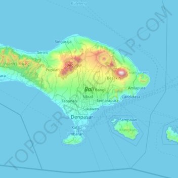
Navn: Topografisk kort Pulau Bali, højde, terræn.
Sted: Pulau Bali, Bali, Lesser Sunda Islands, Indonesia (-8.85003 114.43162 -8.06159 115.71150)
Gennemsnitshøjde: 122 m
Minimum højde: -1 m
Maksimal højde: 2.917 m
Andre topografiske kort
Klik på et kort for at se dets topografi, dets højde og dets terræn.
CitraLand Waterpark Denpasar
Indonesia > Bali > Denpasar > Denpasar Barat > Padangsambian Kaja
Gennemsnitshøjde: 56 m
Point of view on the lake and the mount Batur
Indonesia > Bali > Bangli > Songan B
Gennemsnitshøjde: 1.059 m
Mount Agung
Indonesia > Bali > Karangasem
Australia's Bureau of Meteorology reported on 27 November that ash from the eruption had been observed at an altitude of 9,144 m. By the beginning of December, the eruption reduced to minor emissions of steam and smoke. On 12 December, a picture of the crater was taken showing a steadily growing lava dome…
Gennemsnitshøjde: 2.534 m