
Topografisk kort Finedon
Klik på kortet for at se højden.
Finedon
The town of Finedon rises to approximately 90 metres Above Ordinance Datum from the River Ise, with the historical centre of the settlement occupying a shallow south-west facing valley. The contemporary point of maximum elevation in the parish is the summit of the disused Sidegate Lane Landfill Site, located south of the town at approximately 108 metres Above Ordinance Datum. The parish covers a total area of 1,482 hectares (3,662 acres).
Om dette kort
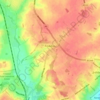
Navn: Topografisk kort Finedon, højde, terræn.
Sted: Finedon, North Northamptonshire, England, United Kingdom (52.31263 -0.68627 52.36156 -0.62272)
Gennemsnitshøjde: 75 m
Minimum højde: 34 m
Maksimal højde: 100 m
Andre topografiske kort
Klik på et kort for at se dets topografi, dets højde og dets terræn.
Irchester Country Park
United Kingdom > England > North Northamptonshire > Little Irchester
Gennemsnitshøjde: 60 m
River Nene Navigation
United Kingdom > England > North Northamptonshire > Irchester
Gennemsnitshøjde: 55 m