
Topografisk kort Pipewell
Klik på kortet for at se højden.
Om dette kort
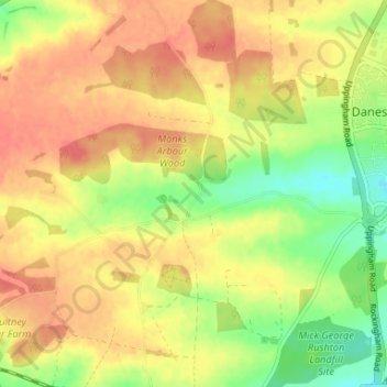
Navn: Topografisk kort Pipewell, højde, terræn.
Gennemsnitshøjde: 124 m
Minimum højde: 93 m
Maksimal højde: 146 m
Andre topografiske kort
Klik på et kort for at se dets topografi, dets højde og dets terræn.
Wellingborough
United Kingdom > England > North Northamptonshire > Great Doddington
Gennemsnitshøjde: 83 m
Irchester Country Park
United Kingdom > England > North Northamptonshire > Little Irchester
Gennemsnitshøjde: 60 m
River Nene Navigation
United Kingdom > England > North Northamptonshire > Irchester
Gennemsnitshøjde: 55 m
Finedon
United Kingdom > England > North Northamptonshire
The town of Finedon rises to approximately 90 metres Above Ordinance Datum from the River Ise, with the historical centre of the settlement occupying a shallow south-west facing valley. The contemporary point of maximum elevation in the parish is the summit of the disused Sidegate Lane Landfill Site, located…
Gennemsnitshøjde: 75 m
Irchester
United Kingdom > England > North Northamptonshire
The 12th-century English historian Henry of Huntingdon mentions a Roman "town on the river (Nene), in Huntingdonshire, which is entirely destroyed" as one of his interpretations of the 28 cities of Britain. The town is mentioned also by William Lambarde in Dictionarium Angliae Topographicum & Historicum.
Gennemsnitshøjde: 62 m
King's Cliffe
United Kingdom > England > North Northamptonshire > King's Cliffe
Gennemsnitshøjde: 69 m
Easton on the Hill
United Kingdom > England > North Northamptonshire > Easton on the Hill
Gennemsnitshøjde: 71 m
Barton Seagrave
United Kingdom > England > North Northamptonshire
Other natives of the village include topographer John Bridges and his brother, Charles, a painter.
Gennemsnitshøjde: 78 m
Irchester
United Kingdom > England > North Northamptonshire
The 12th-century English historian Henry of Huntingdon mentions a Roman "town on the river (Nene), in Huntingdonshire, which is entirely destroyed" as one of his interpretations of the 28 cities of Britain. The town is mentioned also by William Lambarde in Dictionarium Angliae Topographicum & Historicum.
Gennemsnitshøjde: 62 m