
Giv en donation
Gør dig klar til dit næste eventyr:
Som Amazon-partner tjener denne side en kommission på kvalificerede køb uden ekstra omkostninger for dig.
Topografisk kort Mount Bromo
Klik på kortet for at se højden.
Giv en donation
Gør dig klar til dit næste eventyr:
Som Amazon-partner tjener denne side en kommission på kvalificerede køb uden ekstra omkostninger for dig.
Om dette kort
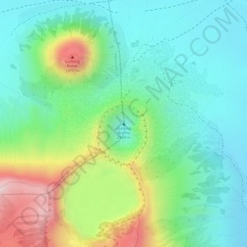
Navn: Topografisk kort Mount Bromo, højde, terræn.
Sted: Mount Bromo, Pasuruan, Indonesia (-7.94212 112.95293 -7.94202 112.95303)
Gennemsnitshøjde: 2.239 m
Minimum højde: 2.110 m
Maksimal højde: 2.504 m
Giv en donation
Gør dig klar til dit næste eventyr:
Som Amazon-partner tjener denne side en kommission på kvalificerede køb uden ekstra omkostninger for dig.
Andre topografiske kort
Klik på et kort for at se dets topografi, dets højde og dets terræn.
Pulau Bali
Bali features a diverse topography shaped by a volcanic origin, which significantly influences its landscapes and climate. The island is dominated by a central mountain range that runs from west to east, with Mount Agung, reaching an elevation of approximately 10,308 feet, standing as the highest peak and a…
Gennemsnitshøjde: 122 m
Giv en donation
Gør dig klar til dit næste eventyr:
Som Amazon-partner tjener denne side en kommission på kvalificerede køb uden ekstra omkostninger for dig.
Borneo
Before sea levels rose at the end of the last Ice Age, Borneo was part of the mainland of Asia, forming, with Java and Sumatra, the upland regions of a peninsula that extended east from present day Indochina. The South China Sea and Gulf of Thailand now submerge the former low-lying areas of the peninsula.…
Gennemsnitshøjde: 141 m
Giv en donation
Gør dig klar til dit næste eventyr:
Som Amazon-partner tjener denne side en kommission på kvalificerede køb uden ekstra omkostninger for dig.
Borneo
Before sea levels rose at the end of the last ice age, Borneo was part of the mainland of Asia, forming, with Java and Sumatra, the upland regions of a peninsula that extended east from present day Indochina. The South China Sea and Gulf of Thailand now submerge the former low-lying areas of the peninsula.…
Gennemsnitshøjde: 141 m
Giv en donation
Gør dig klar til dit næste eventyr:
Som Amazon-partner tjener denne side en kommission på kvalificerede køb uden ekstra omkostninger for dig.
Blitar
Blitar is a landlocked city in East Java, Indonesia, about 73 km from Malang and 167 km from Surabaya. The area lies within longitude 111° 40' – 112° 09' East and its latitude is 8° 06' South. The city of Blitar lies at an altitude on average 167 metres above sea level, and is an enclave within Blitar…
Gennemsnitshøjde: 180 m
Special Capital Region of Jakarta
Jakarta lies in a low and flat alluvial plain, ranging from −2 to 91 m (−7 to 299 ft) with an average elevation of 8 m (26 ft) above sea level with historically extensive swampy areas. Some parts of the city have been constructed on reclaimed tidal flats that occur in around the area. Thirteen rivers flow…
Gennemsnitshøjde: 5 m
Giv en donation
Gør dig klar til dit næste eventyr:
Som Amazon-partner tjener denne side en kommission på kvalificerede køb uden ekstra omkostninger for dig.
Giv en donation
Gør dig klar til dit næste eventyr:
Som Amazon-partner tjener denne side en kommission på kvalificerede køb uden ekstra omkostninger for dig.
Semarang
Semarang is located on the northern coast of Java. The city of Semarang is one of the important cities located on the north coast of Java and as the main hub connecting Jakarta and Surabaya, and cities in the southern interior of Java Surakarta and Yogyakarta. Semarang City has a height ranging from 2 m (6.6…
Gennemsnitshøjde: 107 m
Lombok
Indonesia > West Nusa Tenggara
The island's topography is dominated by the centrally-located stratovolcano Mount Rinjani, the second-highest volcano in Indonesia, which rises to 3,726 metres (12,224 ft), making Lombok the 8th-highest island. The most recent eruption of Rinjani occurred in September 2016 at Gunung Barujari. In a 2010…
Gennemsnitshøjde: 192 m
Giv en donation
Gør dig klar til dit næste eventyr:
Som Amazon-partner tjener denne side en kommission på kvalificerede køb uden ekstra omkostninger for dig.
Giv en donation
Gør dig klar til dit næste eventyr:
Som Amazon-partner tjener denne side en kommission på kvalificerede køb uden ekstra omkostninger for dig.
Bekasi
The City of Bekasi is a part of the Bekasi river basin, located in the downstream area of the basin with slopes ranging from 0 to 2% and elevations between 11 meters to 81 meters above sea level. The city of Bekasi is part of the Bekasi river basin and is located in the downstream area of the basin, with a…
Gennemsnitshøjde: 32 m
Banda Aceh
Banda Aceh (/bʌndəˈɑːtʃeɪ/ BUN-duh-AH-cheh; Acehnese: Banda Acèh, Jawoë: بند اچيه) is the capital and largest city in the province of Aceh, Indonesia. It is located on the island of Sumatra and has an elevation of 35 metres (115 ft). The city covers an area of 61.36 square kilometers (23.69 sq…
Gennemsnitshøjde: 5 m
Giv en donation
Gør dig klar til dit næste eventyr:
Som Amazon-partner tjener denne side en kommission på kvalificerede køb uden ekstra omkostninger for dig.
Giv en donation
Gør dig klar til dit næste eventyr:
Som Amazon-partner tjener denne side en kommission på kvalificerede køb uden ekstra omkostninger for dig.
Giv en donation
Gør dig klar til dit næste eventyr:
Som Amazon-partner tjener denne side en kommission på kvalificerede køb uden ekstra omkostninger for dig.
Giv en donation
Gør dig klar til dit næste eventyr:
Som Amazon-partner tjener denne side en kommission på kvalificerede køb uden ekstra omkostninger for dig.
Temanggung
Temanggung Regency is located on the volcanic Dieng Plateau with an average elevation between 500 and 1450 meters. It is landlocked. The volcanoes Mount Sundoro and Mount Sumbing rise on its border with the Wonosobo Regency. Its major drainage system is the Progo River and its tributaries.
Gennemsnitshøjde: 771 m
Denpasar
Denpasar is located at an elevation of 4 m (13 ft) above sea level. While the total area of 125.98 km2 or 2.18% of the total area of Bali Province. From the use of land, 2,768 hectares of land are paddy, 10,001 hectares are dry land, while the remaining land area is 9 hectares.
Gennemsnitshøjde: 7 m
Giv en donation
Gør dig klar til dit næste eventyr:
Som Amazon-partner tjener denne side en kommission på kvalificerede køb uden ekstra omkostninger for dig.
East Java
East Java has a tropical monsoon and savanna climate at lower elevation and subtropical at higher elevation. Compared with the western part of Java Island, East Java in general has less rainfall. Average rainfall is 1,900 mm per year, with a rainy season during the 100 days. The average temperature ranges…
Gennemsnitshøjde: 62 m
Giv en donation
Gør dig klar til dit næste eventyr:
Som Amazon-partner tjener denne side en kommission på kvalificerede køb uden ekstra omkostninger for dig.
Bali
Bali's central mountains include several peaks over 2,000 metres (6,600 feet) in elevation and active volcanoes such as Mount Batur. The highest is Mount Agung (3,031 m, 9,944 ft), known as the "mother mountain", which is an active volcano rated as one of the world's most likely sites for a massive eruption…
Gennemsnitshøjde: 88 m
Giv en donation
Gør dig klar til dit næste eventyr:
Som Amazon-partner tjener denne side en kommission på kvalificerede køb uden ekstra omkostninger for dig.
City of Medan
Medan's elevation varies between 2.5 and 37.5 m (8 ft 2 in and 123 ft 0 in) above sea level, with the Barisan Mountains to the south, and volcanoes such as Sibayak Mountain and Sinabung Mountain 50 to 70 km (31 to 43 mi) from the city.
Gennemsnitshøjde: 19 m
Giv en donation
Gør dig klar til dit næste eventyr:
Som Amazon-partner tjener denne side en kommission på kvalificerede køb uden ekstra omkostninger for dig.
Giv en donation
Gør dig klar til dit næste eventyr:
Som Amazon-partner tjener denne side en kommission på kvalificerede køb uden ekstra omkostninger for dig.
Taman Rekreasi Sengkaling UMM
Indonesia > Kabupaten Malang > Mulyoagung > Dawuhan
Gennemsnitshøjde: 580 m
Giv en donation
Gør dig klar til dit næste eventyr:
Som Amazon-partner tjener denne side en kommission på kvalificerede køb uden ekstra omkostninger for dig.
Tangerang
Topographically, Tangerang City is mostly located at an altitude of 10-30 meters above sea level, aka the whole area is in the lowlands. The northern part of the city (covering most of Benda District) has an average height of 10 meters above sea level, while the southern part of Tangerang City has a height of…
Gennemsnitshøjde: 16 m
Borneo
Before sea levels rose at the end of the last ice age, Borneo was part of the mainland of Asia, forming, with Java and Sumatra, the upland regions of a peninsula that extended east from present day Indochina. The South China Sea and Gulf of Thailand now submerge the former low-lying areas of the peninsula.…
Gennemsnitshøjde: 141 m
Giv en donation
Gør dig klar til dit næste eventyr:
Som Amazon-partner tjener denne side en kommission på kvalificerede køb uden ekstra omkostninger for dig.
Muara Enim
The resulting twenty-two districts (including the six now in the new Rambang Lubai Lematang Regency) are listed below with their areas and their populations at the 2010 Census and the 2020 Census, together with the official estimates as at mid 2022. The table also includes the locations of the district…
Gennemsnitshøjde: 212 m
Giv en donation
Gør dig klar til dit næste eventyr:
Som Amazon-partner tjener denne side en kommission på kvalificerede køb uden ekstra omkostninger for dig.
South Barito
Indonesia > Central Kalimantan
Regency's topography is flat and low-lying but on the most part except on northern parts where mountain ranges could be found. The regency's low-lying regions are wetlands and swamps with little variations.
Gennemsnitshøjde: 38 m
Giv en donation
Gør dig klar til dit næste eventyr:
Som Amazon-partner tjener denne side en kommission på kvalificerede køb uden ekstra omkostninger for dig.
Giv en donation
Gør dig klar til dit næste eventyr:
Som Amazon-partner tjener denne side en kommission på kvalificerede køb uden ekstra omkostninger for dig.
Kendari
Indonesia > Southeast Sulawesi
Kendari borders the Konawe Regency in the north, South Konawe Regency in the south and west, and Kendari Bay in the east. The city is on the southeastern part of mainland Sulawesi island; several smaller islands around the bay are within its boundaries. The city's topography varies from flat to hilly. Coastal…
Gennemsnitshøjde: 67 m
Giv en donation
Gør dig klar til dit næste eventyr:
Som Amazon-partner tjener denne side en kommission på kvalificerede køb uden ekstra omkostninger for dig.
Bali
Bali's central mountains include several peaks over 2,000 metres (6,600 feet) in elevation and active volcanoes such as Mount Batur. The highest is Mount Agung (3,031 m; 9,944 ft), known as the "mother mountain", which is an active volcano rated as one of the world's most likely sites for a massive eruption…
Gennemsnitshøjde: 88 m
Giv en donation
Gør dig klar til dit næste eventyr:
Som Amazon-partner tjener denne side en kommission på kvalificerede køb uden ekstra omkostninger for dig.
Aceh Tengah
Central Aceh District is a highland area with an altitude between 200 – 2600 metres above sea level and with an area of 4,527.53 km2.
Gennemsnitshøjde: 936 m
Giv en donation
Gør dig klar til dit næste eventyr:
Som Amazon-partner tjener denne side en kommission på kvalificerede køb uden ekstra omkostninger for dig.
Java
Java is an island with a large amount of biodiversity. The natural environment of Java is tropical rainforest, with ecosystems ranging from coastal mangrove forest on the north coast, rocky coastal cliffs on the southern coast, and low-lying tropical forest to high altitude rainforest on the slopes of…
Gennemsnitshøjde: 39 m
Giv en donation
Gør dig klar til dit næste eventyr:
Som Amazon-partner tjener denne side en kommission på kvalificerede køb uden ekstra omkostninger for dig.